From Wikipedia, the free encyclopedia

EO-1 Satellite Image of Enewetak Atoll. The crater formed by the Ivy Mike nuclear test can be seen on the northeast cape of the atoll.
|
|

|
|
| Geography | |
|---|---|
| Location | North Pacific |
| Coordinates | 11°30′N 162°20′ECoordinates: 11°30′N 162°20′E |
| Archipelago | Ralik |
| Total islands | 40 |
| Area | 5.85 km2 (2.26 sq mi) |
| Highest elevation | 5 m (16 ft) |
| Country | |
| Demographics | |
| Population | 853 (as of 1998) |
| Ethnic groups | Marshallese |


Contents
Geography
Enewetak Atoll formed atop a seamount. The seamount was formed in the late Cretaceous (about 75.8 million years ago).[4] This seamount is now about 4,600 feet (1,400 m) below sea level.[5] The seamount is made of basalt, and its depth is due to a general subsidence of the entire region and not because of erosion.[6]Enewetak has a mean elevation above sea level of 10 feet (3.0 m).[7]
History
Humans have inhabited the atoll since about 1,000 BCE.[8] The first European visitor to Enewetak, Spanish explorer Alvaro de Saavedra, arrived on 10 October 1529.[9][10] In 1794 sailors aboard the British merchant sloop Walpole called the islands "Brown's Range" (thus the Japanese name "Brown Atoll"). It was visited by about a dozen ships before the establishment of the German colony of the Marshall Islands in 1885. Along with the rest of the Marshalls, Enewetak was captured by the Imperial Japanese Navy in 1914 during World War I and mandated to the Empire of Japan by the League of Nations in 1920. The Japanese administered the island under the South Pacific Mandate, but mostly left local affairs in hands of traditional local leaders until the start of World War II.In November 1942, the Japanese built an airfield on Engebi Island; because they used it only for refueling planes between Truk and islands to the east, no flying personnel were stationed there and the island had only token defenses. When the Gilberts fell to the United States, the Imperial Japanese Army assigned the 1st Amphibious Brigade, a unit formed from the 3rd Independent Garrison unit previously stationed in Manchukuo, to defend the atoll. The 1st Amphibious arrived on January 4, 1944. Of the 3,940 men in the brigade, 2,586 were left to defend Eniwetok Atoll, supplemented by aviation personnel, civilian employees, and laborers, but were unable to finish fortifying the island before the American assault. During the Battle of Eniwetok in February 1944, the United States captured Enewetak in a five-day amphibious operation, with major combat on Engebi Islet, the most important Japanese installation on the atoll. Combat also occurred on the main islet of Enewetak itself and on Parry Island, site of a Japanese seaplane base.
Following its capture, the anchorage at Enewetak became a major forward naval base for the U.S. Navy. The daily average of ships present during the first half of July 1944 was 488; during the second half of July the daily average number of ships at Enewetak was 283.[11] In 1950, John C. Woods, who executed the Nazi war criminals at the Nuremberg Trials, was accidentally electrocuted here, and he died as a result.
Following the end of World War II, Enewetak came under the control of the United States as part of the Trust Territory of the Pacific Islands until the independence of the Marshall Islands in 1986. During its tenure, the United States evacuated the local residents many times, often involuntarily,[citation needed] and the atoll was used for nuclear testing as part of the Pacific Proving Grounds. Before testing commenced, the U.S. exhumed the bodies of United States servicemen killed in the Battle of Enewetak and buried there and returned them to the United States to be re-buried by their families. Forty-three nuclear tests were fired at Enewetak from 1948 to 1958.[12] The first hydrogen bomb test, code-named Ivy Mike, occurred in late 1952 as part of Operation Ivy; it vaporized the islet of Elugelab. This test included the use of B-17 Flying Fortress drones to fly through the radioactive cloud for the purpose of testing onboard samples. B-17 mother ships controlled the drones while flying within visual distance of them. In all 16 to 20 B-17s took part in this operation, of which half were controlling aircraft and half were drones. For examination of the explosion clouds of the nuclear bombs in 1957/58 several rockets (mostly from rockoons) were launched.

Section 177 of the 1983 Compact of Free Association between the Government of the United States and the Government of the Marshall Islands[19] establishes a process for Marshallese to make a claim against the United States government as a result of damage and injury caused by nuclear testing. That same year, an agreement was signed to implement Section 177 which established a $150 million trust fund. The fund was intended to generate $18 million a year, which would be payable to claimants on an agreed-upon schedule. In the event the $18 million a year generated by the fund was not enough to cover claims, the principal of the fund could be used.[20][21] A Marshall Islands Nuclear Claims Tribunal was established to adjudicate claims. In 2000, the tribunal made a compensation award to the people of Enewetak consisting of $107.8 million for environmental restoration; $244 million in damages to cover economic losses caused by loss of access and use of the atoll; and $34 million for hardship and suffering.[21] In addition, as of the end of 2008, another $96.658 million in individual damage awards were made. Only $73.526 million of the individual claims award has been paid, however, and no new awards were made between the end of 2008 and May 2010.[21] Due to stock market losses, payments rates which have outstripped fund income, and other issues, the fund was nearly exhausted as of May 2010 and unable to make any additional awards or payments.[21] A lawsuit by Marshallese arguing that "changed circumstances" made Nuclear Claims Tribunal unable to make just compensation was dismissed by the Supreme Court of the United States in April 2010.[22]
The 2000 environmental restoration award included funds for additional cleanup of radioactivity on Enewetak. Rather than scrape the topsoil off the island, replace it with clean topsoil, and create another radioactive waste repository dome at some site on the atoll (a project estimated to cost $947 million), most areas still contaminated on Enewetak itself were treated with potassium.[23] Soil which could not be effectively treated for human use was removed and used as fill for a causeway connecting the two main islands of the atoll (Enewetak and Parry). The cost of the potassium decontamination project was $103.3 million.[21]
Summary of nuclear tests at Eniwetok
| Series | Start Date | End Date | Count | Yield Range | Total Yield |
|---|---|---|---|---|---|
| Sandstone | 14 April 1948 | 14 May 1948 | 3 | 18 - 49 kilotons | 104 kilotons |
| Greenhouse | 7 April 1951 | 4 May 1951 | 4 | 45.5-225 kilotons | 399 kilotons |
| Ivy | 31 October 1952 | 15 November 1952 | 2 | 500 kilotons - 15 megatons | 15.5 megatons |
| Castle Nectar | 20 April 1954 | 20 April 1954 | 1 | 1 - 3 megaton | 1.69 megaton |
| Redwing | 4 May 1956 | 21 July 1956 | 11 | 190 tons - 1.89 megatons | 2.555 megatons |
| Hardtack I | 28 April 1958 | 18 August 1958 | 26 | Zero - 9.3 megatons | 16.005 megatons |
| Total | 47 | 36.2363 megatons (6.9% of total test yield worldwide) |
Eniwetok Airfield
Men from the 110th Naval Construction Battalion arrived on Eniwetok between 21 and 27 February 1944 and began clearing the island for construction of a bomber airfield. A 6,800-foot (2,100 m) by 400-foot (120 m) runway together with taxiways and supporting facilities was built. The first plane landed on 11 March and by 5 April the first operational bombing mission was conducted.[24] The base was later named for Lieutenant John H. Stickell.[25][26]In mid-September 1944 operations at Wrigley Airield on Engebi Island were transferred to Eniwetok.[27]
US Navy and Marine units based at Eniwetok included:
- VB-102 operating PB4Y-1s from 12–27 August 1944[28]
- VB-108 operating PB4Y-1s from 11 April-10 July 1944[29]
- VB-109 operating PB4Y-1s from 5 April-14 August 1944[30]
- VB-116 operating PB4Y-1s from 7 July-27 August 1944[31]
- VPB-121 operating PB4Y-1s from 1 March-3 July 1945[32]
- VPB-144 operating PV-2s from 27 June 1945 until September 1946[33]
Parry Island seaplane base
The Imperial Japanese Navy had developed a seaplane base on Parry Island and following its capture on 22 February Seebees from the 110th Naval Construction Battalion expanded the existing base building a coral-surfaced parking area and shops for minor aircraft and engine overhaul. A marine railway was installed on an existing Japanese pier and boat-repair shops were also erected.[34]US Navy and Marine units based at Parry Island included:
- VP-13 operating PB2Y-3s from 26 February-22 June 1944[35]
- VP-16 operating PBM-3Ds from 7 June-1 August 1944[35]
- VP-21 operating PBM-3Ds from 19 August-17 October 1944 and from 15 July-11 September 1945[36]
- VP-23 operating PBY-5As from 20 August 1944-9 April 1945[37]
- VP-MS-6 operating PBM-5Es from 1 February 1948 in support of Operation Sandstone[38]
- VP-102 operating PB2Y-3s from 3 February-30 August 1944[39]
- VP-202 operating PBM-3Ds from 24 February-1 March 1944[40]
- VPB-19 operating PBM-3Ds from 2 November 1944-12 February 1945 and 6 March 1945-January 1946[41]
- VPB-22 operating PBM-3Ds from 10 October-30 November 1944 and from 25 June-7 August 1945[42]
Gallery
-
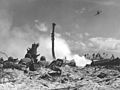 Battle of Eniwetok
 -
 B-17 drone at Eniwetok Airfield in 1948 for Operation Sandstone
 -
 Operation Sandstone
 -
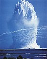
 Ivy Mike test, October 31, 1952
 -
 Operation Greenhouse test
 -
 Ivy King test, November 1952
 -
 Red-wing Seminole test
 -
 Red-wing Seminole test
 -
 Hardtack Umbrella test
 -
Test shot Nectar of Operation Castle produced a yield of 1.69 megatons and was detonated in Ivy Mike's Elugelab crater. Note the distinctive near instantaneous double flash, with the second appearing brighter than the sun, and the blast wave slowly, by comparison, spreading out turning the calm ocean water a distinctive frothy white as it arrives. The Island of Bogon is the spear head shaped object at the bottom right of the screen. The nuclear fireball's radius is approximately 2.5 km.[43]


No comments:
Post a Comment